The price depends on the size of the pig, a price list will be added here in the next couple days.

Camiguin is an island province of the Philippines located in the Bohol Sea, about ten kilometers off the northern coast of Misamis Oriental in Mindanao.
Geographic Location - Camiguin is a small, pear-shaped island province in the northern tip of Mindanao. The province is located just off the coast of northern Mindanao. It is 10 kilometers north of Misamis Oriental and 54 kilometers southeast of Bohol. The island is separated from mainland Mindanao in the south by Gingoog and Macajalar Bays, in the east by Butuan Bay, and from the Visayas in the north by the Bohol Sea.
Land Area - The Island of Camiguin has a total land area of 238 square kilometers and measures approximately 37 kilometers at its longest side and 14 kilometers at its widest breadth. In terms of land area, it is the second smallest province in the Philippines and roughly its land area is only around 2% of Region X. Of the five municipalities comprising the province, Mambajao is the biggest in terms of land area, having 37.40% (89.00 sq. km) of the total land area of the island. The second largest municipality is Catarman which comprises 22.59% (53.75 sq. km) of the total land area of the province. This is followed by the municipalities of Sagay and Mahinog comprising 18.55% (44.13 sq. km) and 13.68% (32.55 sq. km) of Camiguin's total land area, respectively. Guinsiliban, the smallest municipality, makes up only 7.78% (18.52 sq. km) of the province's total land area. The five municipalities are further divided into 58 barangays and are distributed as follows: 15 in Mambajao, 13 in Catarman, 11 in Mahinog, 9 in Sagay and 7 in Guinsiliban.
Topography - Camiguin is a volcanic island whose physical form consists of seven volcanoes, both active and dormant. The island is the northern extension of the Misamis Peninsula and is part of the Northern Mindanao earthquake epicenter. It is basically volcanic in origin and is entirely made up of deposits attributed to its volcanoes. The highest peak in the island is Mt. Timpoong which rises 1,580 meters above sea level. Because of the island's volcanic form, several hot sulfur springs and geothermal vents exist. Dominated by high volcanic peaks, Camiguin has a small surrounding area of flat lowland terrain. These are found in the coastline area and as one moves toward the middle of the island, the terrain becomes steep with several highland plateaus. Nearly 75% of the island coastline consists of coral reef formations. The rest is primarily rocky volcanic formations or sandy surfaces. There are two small coral islets that surround Camiguin, White Island and Mantigue Island.
Climate - The province of Camiguin has a type II climate and the mean annual temperature is 23.64 degress Centigrade. The lowest temperature of the province averages around 23.41 degrees Centigrade between the months of April and August. The relative humidity in the province averages near 76.77% all year round. The province has a pronounced rainy season between the months of November and February and the absence of a definite dry season. Rainfall distribution of the province indicates that the northeastern part of the island receives an average of 2,300 mm of rainfall, due to the northeast monsoons. the western part of the island receives a slightly lower rainfall of 2,000 mm, while the months between October and February receives the longest amount of precipitation. In the months between October and January the province is always visited by typhoons from the southeast creating high winds and rain occurrences.
 |  |  |  |
| The Port of Balbagon is nearest Mambajao town | Mantigue Island as seen from Mahinog | Small fishing village in Sagay | Quarrying for sand and gravel in the Municipality of Sagay |
 |  |  |  |
| Camiguin Airport as seen from the PHIVOLCS station | A black sand beach at Barangay Yumbing | Recent rockslide at Hubangon that killed people | The Catarman side of the Camiguin province |
 |  |  |  |
| Waiting Shed along the cir- cumferential road at Mahinog | A communication tower at the Municipality of Mahinog | The Port of Benoni | A small barangay in Mahinog |
 |  |  |  |
| A two-lane concrete paved road at Mahinog | Mantigue (Magsaysay) Island | A ricefield in Sagay | White Island as seen from the PHIVOLCS station |
 |  |  |  |
| Two-lane concrete road at the Catarman side | The circumferential road at vicinity of Barangay Agoho | Coastline at the eastern side of Camiguin Island | The coastal road at the Municipality of Mahinog |
 |  |  |  |
| A concrete bridge in the Municipality of Sagay | Mt. Timpoong and a small farm near Mambajao | A typical motorized banca used for fishing | Coconut trees grow abun- dantly around Camiguin Island |
Population
As a province, Camiguin has the least population in Northern Mindanao (Region X) and second to the smallest in the Philippines. In 1995, the population of Camiguin was 68,039, exceeding the official projection of 67,843 made by the National Statistics Office. This population count represents a 5.9% growth from the population of 1990, increasing the population density of the province from 264 persons per square kilometer in 1990 to 280 persons per square kilometer in 1995.
The municipality of Mambajao with 27,770 persons (40.8% of Camiguin's total population), had the largest share of the population in 1995. This was followed by the municipality of Catarman with a population of 14,756 (21.7% of Camiguin's population). The municipality of Mahinog and Sagay came in third and fourth with a population of 11,351 persons (16.7% of Camiguin's population) and 9,243 (13.6% of Camiguin's population), respectively. With only 4,919 persons, the municipality of Guinsiliban has the smallest population which is 7.2% of the total population of the province.
Despite its small population, Guinsiliban registered the highest average population growth rate of 2.37% from 1990 to 1995, much higher than Mambajao's 1.83%. Sagay, on the other hand, experienced a negative growth rate of 0.50% during the same period. The rate of growth of Camiguin's population slowed down from an annual average of 1.18% (1980-1990) to 1.08% from 1990 to 1995. Overall, these figures still fall way below the average population growth rate of 2.35% for the whole country.
With respect to population distribution by gender, there are slightly more males than females in Camiguin. The sex ratio (number of males per 100 females) increased from 102.4 in 1980 to 105.4 in 1990. By 1995, the ratio only slightly decreased by 105. The population of the island province is relatively young, with nearly 39% below 15 years of age in 1995, or nearly two-thirds under the age of 30. Among those under 30 years old, males outnumber the females with a sex ratio of 109, a figure which is higher than the provincial ratio of 105 for the whole population in 1995. At the other end of the age scale, the number of aged females, 70 years old and above, outnumbered their male counterparts with a sex ratio (number of females per 100 males) of 125 in 1995. This indicates that the women of Camiguin have a higher life expectancy than the menfolk.
Population DensityIn terms of population density, there is an unequal distribution of population across the area. There is a pattern of coastal villages having the highest in population density while the upland areas are the most sparsely populated. The population density (number of persons per sq. kilometer) for each municipality is as follows: Mahinog (348), Mambajao (312), Catarman (275), Sagay (209), and Guinsiliban (205). The most densely populated area is the coastal village of Benoni in Mahinog which is the main sea port of the island. It has a population density of 1,415 inhabitants per square kilometer. Other densely populated villages are Looc in Catarman and Balite in Guinsiliban with 1,109 and 1,062 inhabitants per square kilometer. Both villages are also coastal. The most sparsely populated are the upland villages of Balite and Cuna in Sagay with a population density of 50 and 81 inhabitants per square kilometer, respectively.
InfrastructureThe Island of Camiguin has an arterial circumferential road 64.1 km long. Of this length 12.15 km are concrete, 39.27 are bituminous surface, and 12.65 km are unpaved. Twenty of the twenty-one bridges on this road are now standardized concrete structures. The provincial roads which serve as collector roads has a total length of 97.93 km. There are thirty-three of these which originate from the national road junction which serve as Farm-to-Market roads and some are roads that lead to tourist spots. The priority established by the provincial government is to concrete roads leading to tourist spots. The existing Camiguin Airport is continuously being improved and recently concrete has replaced the bituminous surface of the runway including the apron.
Camiguin obtains its power from the Napocor Hydroelectric plant in mainland Mindanao. Power reaches the island through a 10.6 km submarine cable. The Camiguin Electric Coop transformer has a 5 MVA capacity. The substation's transformer has only a 28% loading, hence adequate power supply is available for the whole island. All of the 58 barangays in the 5 municipalities are already energized.
It has been said that Camiguin probably has the best rural telecommunication facilities in the country which is operated by the Camiguin Telephone Cooperative (CAMTECO). In a recent report, there are more than four hundred subscribers around the island with 100% direct-dialing access to the national and international network. Local calls are metered to prevent unnecessary long use of phones in order to provide optimum service to all. The potential capacity of CAMTECO can reach 1024 subscribers without major expansion on its existing equipment. The government operates telegraph services in the municipalities of Mambajao and Catarman. All municipalities have postal services with a total of 22 letter carriers.
In the province, health services are provided by the government through three hospitals, rural health units and barangay health stations. The Camiguin Island Hospital serves the island with 100 beds. Catarman District Hospital has 25 beds and Sagay Medicare Hospital with 15 beds. These health facilities provide a wide range of services to the island residents such as emergency services, long-range health care, pediatrics and preventive health services.


There are two schools offering college courses in education: Fatima College of Camiguin in Mambajao and a satellite college at Tangaro, Catarman of the Central Mindanao University in Musuan, Bukidnon. There is only one school specializing in vocational education, the Camiguin Polytechnic State College. It offers vocational secondary education and two-year technical courses. The college is considering an expansion of its course offerings with a view to offer classes in poverty studies and bio-diversity.


The ABC Gym is the only multi-purpose recreational center in Mambajao. Mahinog, Sagay, Catarman have also their own gym. There is no movie house in the province but there are DVD movies for sale for those who own DVD players. Satellite TV services are provided by the Camiguin Island Cable in the municipalities of Mambajao and Mahinog. All municipalities have their cockpit for cockfighting aficionados. Basketball courts are found in every barangay and tennis courts in every municipality.
Local EconomyCamiguin has practically no industry to speak of. More than 18 percent of 517 establishments registered are engaged in wholesale and retail trade and services. More than 50 percent of these establishments are in the capital town of Mambajao. The provincial economy is predominantly agricultural, with an incipient tourism industry. The dependence on agriculture and fishing in a province with limited arable land, low agricultural productivity, dwindling natural resources and practically no value-adding activities, is one of the major factors for a 71 percent poverty incidence, the highest in Region X.
Household earnings less than the approximated 1996 regional poverty threshold of P51,563 comprised 71.14% of the total number of households surveyed. The poverty incidence is highest in the Municipality of Guinsiliban at 81 percent of surveyed households, followed by Sagay with 75 percent. The rate is lowest at 67 percent in Mambajao. Mahinog has a 73 percent poverty incidence and Catarman having a 71 percent rate. The 1996 survey reveals that 51.15% of household's source of income is from agriculture (farming and fishing), 24.53% from labor or employement, 9.82% from business enterprises (mainly trading and services), and 14.48% from other sources (receipts from abroad, pensions, rentals, interest earnings, investment dividends, etc.). The survey also shows that 44% of households cite a secondary source of income, while 6% indicate a third source. In addition, the survey revealed that Camiguin households spend an average of P2,025 monthly on food, P748 for education, P344 on clothing, P317 for medicine and P237 for recreation. Aside from these, the households incurred an average expenditure of P2,769 in 1996 for their annual fiesta.
The name Camiguin is derived from the native word "Kamagong," a tree of the Ebony family that thrives near Lake Mainit in the Province of Surigao del Norte. The original inhabitants of Camiguin were "Manobos" who migrated from Surigao. Thge old native language in Camiguin is called "Kinamiguin," which is similar to the dialect spoken in Surigao. Camiguin was part of the province of Misamis Oriental from 1946 to 1958. It became a sub-province in 1958 and finally in 1968, a full-pledged province with Mambajao as its provincial capital.
Spanish PeriodOld Spanish documents indicate that the renowned explorers, Ferdinand Magellan and Miguel Lopez de Legaspi landed in Camiguin in 1521 and 1565, respectively. The first Spanish settlement in what was later to be known as Guinsiliban was established in 1598. Guinsiliban comes from the old Kinamiguin word "guinsilipan" which means "to look out for pirates from a watchtower." An old Spanish watchtower where the Camiguinians kept watch for Moro pirates still stands in Guinsiliban.
The first major Spanish settlement established in 1679 was called Katagman or Katadman (now known as Catarman). This settlement grew and prospered to what is now Barangay Bonbon. On May 1, 1871, Mt. Vulcan Daan erupted and destroyed the town. A portion of the town sank beneath the sea. After the eruption, the settlement moved to where the Catarman town center is presently located. Today, all the remains of old Catarman are the ruins of the ancient Spanish church, a convent and a bell tower.
Sagay, located south of Catarman, was formally established as a town in 1848. The word Sagay is derived from the name of a poisonous fruit tree that grew in the area. Mambajao, the capital of Camiguin province, became a town in 1855. The name was coined from the Visayan terms "mamahaw," meaning to usher breakfast, and "bajao," which is leftover boiled rice. In the early 1900s, Mambajao prospered to become the busiest port in Northern Mindanao. Mahinog was established as a municipality in 1860. The name Mahinog comes from a Cebuano word meaning "to ripen" or "to become ripe." Although Guinsiliban was the oldest settlement in the island, it was only in 1950 when it became a municipality. Both Mahinog and Guinsiliban were formally governed from Sagay.
American PeriodIn 1901, in the middle of the Spanish-American War (1898-1904), American soldiers landed in Camiguin to assume political control over the island. A group of Camiguinians, armed with bolos and spears, led by Valero Camaro fought for the island's independence from foreign invasion during a short battle in Catarman. Camaro was killed by a bullet on the forehead. He became one of the unsung Camiguin patriots of the early independence movement. In 1903, the first public school in Camiguin was built in Mambajao and in 1904, the first public water system was installed. On June 18, 1942, the Japanese Imperial Army landed in Camiguin and set up a government in Mambajao. The Japanese Army gutted down central Mambajao in reprisal to guerrilla activities there. The remains of some of these buildings still exist today.
The island of Camiguin is part of the Northern Mindanao earthquake epicenter. It is basically volcanic in origin and is entirely made up of deposits attributed to its volcanoes. This volcanic island consists of the following seven volcanoes which have shaped both the land and the culture of its inhabitants:
Mt. Hibok-Hibok Mt. Vulcan Mt. Guinsiliban Mt. Mambajao Mt. Timpoong Mt. Tres Marias Mt. Uhay
There are also quite a number of smaller volcanic domes and parasitic cones such as Mt. Carling, Mt. Tibane and Piyakong Hill at the flanks of Mt. Hibok-Hibok, Campana Hill, Minokol Hill and the Tres Marias Hill at the flanks of Mt. Mambajao. Mt. Hibok-Hibok is an active volcano. It continues to manifest seismic activity and it only has a short repose period. The other six volcanoes are inactive, having no continued record of eruptions and their forms have started to change due to the agents of weathering and erosion and the formation of deep and long gullies on its slopes.
 |  |  |
| Mt. Timpoong | Mt. Hibok-Hibok | Mt. Vulcan |
 |  |  |
| Mt. Guinsiliban | Mt. Uhay | Mts. Vulcan & Hibok-Hibok |
The highest peak in the island is Mt. Timpoong which rises 1,580 meters (5,184 feet) above sea level. Mt. Mambajao stands 1,420 meters (4,659 feet) and Mt. Hibok-Hibok rises 1,240 meters (4,068 feet) above sea level. Not only is Mt. Mambajao the tallest, it is also the biggest volcano in the island. Because of the island's volcanic form, several hot sulfur springs and geothermal vents exists.
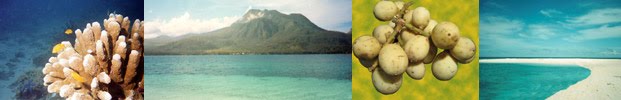
The volcanoes and the terrain of Camiguin Island pose limits on current and potential land use, and consequently, on the province's economic development. On the other hand, these qualities, particularly the volcanoes, make Camiguin unique and potentially enhance its attractiveness as a tourist destination. Despite the considerable destruction wrought by Hibok-Hibok's eruption in the early 1950s, Camiguin Island has flourished on its volcanic soils. The fertility of which has made the island conducive for the cultivation of coconut, copra, and other agricultural products.
MT. HIBOK-HIBOKLooming up behind the small capital town of Mambajao is Mt. Hibok-Hibok. This active volcano almost oblitereated the capital by a major eruption which started in September 1948 and lasted until 1953. Its minor eruption in 1948 caused little damage and loss of life. In 1949, its eruption caused 79 deaths due to landslides. In the morning of December 4, 1951, the most violent phase of the volcano's eruption occured. This time it unleased boiling lava which rolled down swifty toward Mambajao which was accompanied by poisonous gases, and landslides enough to destroy nearly 19 square kilometers of lands.
The speed and the high temperature of the avalanche which reached 800 degrees Celsius caused considerable damage in the affected areas. Trees were felled and charred, houses were burned down, animals and people were either charred or mummified. The eruption claimed more than 500 human lives and damaged properties and structures worth millions of pesos. Before the eruption of Mt. Hibok-Hibok in 1951, the population of Camiguin had reached 69,000. After the eruption, the population was reduced to about 34,000 due to mass departure of the island residents. In the years that followed, Camiguin's population grew from 57,126 in 1980 to 64,247 in 1990 an increase of 7,121 persons or 12.47 percent. In the last population count in 1995, there were already 68,039 residents which is just a little lower than its original population prior to the 1951 eruption.
The eruption of Mt. Hibok-Hibok has been classified as "Pelean," an eruption type considered to be one of the most dangerous because it is characterized by extrmemly viscous lava and the formation of glowing clouds of gas. The three photographs portrayed below were taken during the 1951 eruption of Mt. Hibok-Hibok.


Mt. Hibok-Hibok is an incandescent volcano and it consumes vast quantities of oxygen during an eruption that it kills by asphyxiation. After its major eruption in 1951, many persons were found dead as if they were merely asleep. This eruption prompted the Philippine government to create the Commission on Volcanology which is presently known as PHIVOLCS (Philippine Institute of Volcanology & Seismology).
The first recorded eruption of Hibok-Hibok ocurred in 1827. This was followed by a similar activity in 1862. Both eruptions caused destruction to arable lands. In the eruption of 1862, there were 326 deaths caused by ashflows that reached the sea. Some people drowned while trying to flee in small boats. In January 1871, earthquakes and subterranean rumbling sounds disturbed the northern end of Camiguin Island. Landslides and fissuring destroyed trees and plantations. When the swarm of earthquake ceased in April of the same year, an explosion followed and was accompanied by a shower of rocks, dust, and ashes. Destruction was complete within a radius of 1.86 miles (3 kilometers) from the new vent.
The eruption continued for a week and a volcanic dome called Vulcan began to form 2.17 miles (3.5 kilometers) from the general area of Mt. Hibok-Hibok. During this eruption most of the local residents fled the area after earthquakes that preceded the eruption. After four years of activity, the adventive lava dome reached a height of 1,500 feet (457 meters) with a base nearly 0.93 miles (1.5 kilometers) in diameter.
In 1897, the area occupied by the present dome of Mt. Hibok-Hibok emitted white sulfurous vapors which ruined agricultural lands nearby. Solfataric activity continued up to 1902 when a thunder storm occurred around the volcano and a new solfataric vent formed opposite the crest. Frequent subterranean sounds were noted during the activity which lasted for 8 to 10 days.
In every few years of activity, Mt. Hibok-Hibok seems to follow a cycle of behavior consisting of a short period of smoke emission from the crater and an avalanche of volcanic materials with or without accompanying tremors. There are explosions or steam blasts with emission of heavy clouds of steam, ashes and other fragmentary volcanic materials. The whole cycle covers a period of 9 to 14 months. Cold and hot mud flows, or lahar, develops especially after heavy rains so that now they pose another hazard to inhabitants living near the drainage channels of the volcano.
The approach for climbing Mt. Hibok-Hibok is at its base in Barangay Esperanza in Mambajao. Its steep slopes is a challenge to most seasoned climbers as the climb entails maneuvers in loose rocks and boulders. A dense, primeval forest covers every square foot of ground. There are tree ferns that thrive in the cool shade and springs bubble out of the ground. The summit of Mt. Hibok-Hibok is covered with loose ejecta and it has several craterlets at or near the crest, some representing shallow lakes. The present crateral area at the northeast slope facing Mambajao was mined for sulfur before the volcano's activity in 1948. At its crater is a lake and there are numerous steam vents and outlets which can be found at different locations.
Those who make the climb to its summit are rewarded with a magnificent panoramic view of the entire island including the nearby island of Bohol which can be seen on clear days. Although this mist-covered volcano is now quiet and inactive, the PHIVOLCS continue to monitor any unusual seismic activities for the safety of visitors and residents of the island. For those who intend an ascent of Mt. Hibok-Hibok, it is advisable to first pay a visit to the research and monitoring station to determine if it would be safe to make the climb. The station is located at 1,300 feet (396 meters) up on its slope.
| The proximity of the project to the magnificent and fascinating three (3) acres of live coral reefs under a crystal clear deep blue sea, located just twenty (20) meters away from its beach front, has greatly influenced the christening of the project. Reputedly known as one of the three (3) ancient civilizations in Mindanao, the Municipality of Catarman, formerly known as Partido de Catarman, hosts the majority of the tourist spots in the island of Camiguin, namely: | ||||||||||||||
|  | |||||||||||||
| Government Health and Safety Facilities: | ||||||||||||||
| ||||||||||||||
| How To Reach Catarman Coral Dive Resort? | ||||||||||||||
Foreign and domestic tourists from Manila can take any of the six (6) flights daily bound for Cagayan de Oro City, and from there hire a taxi or van bound for the Port of Balingoan, Misamis Oriental, then take a ferry to the ports of Guinsiliban or Benoni. The foreign and domestic tourist from Cebu can also take a direct 8:00 A.M. flight to Mambajao, Camiguin on Monday, Wednesday and Friday or take a ferry every 8:00 P.M. on Friday only. The management will pickup the guests from the ports for those who already made advance reservation. | ||||||||||||||
| ||||||||||||||
| ||||||||||||||||
| ||||||||||||||||
| ||||||||||||||||
| ||||||||||||||||
| ||||||||||||||||
| ||||||||||||||||
| ||||||||||||||||||||||||||||||
| ||||||||||||||||||||||||||||||


